About The Formation of Cappadocia
This page contains the most valuable information about Cappadocia, which are derived from several academic article and publishing. You will get very unique knowledge while you are reading . Please keep them on your mind and compaire in your holiday in the Cappadocia.
FORMATION AND HISTORICAL GEOGRAPHY OF CAPPADOCIA REGION
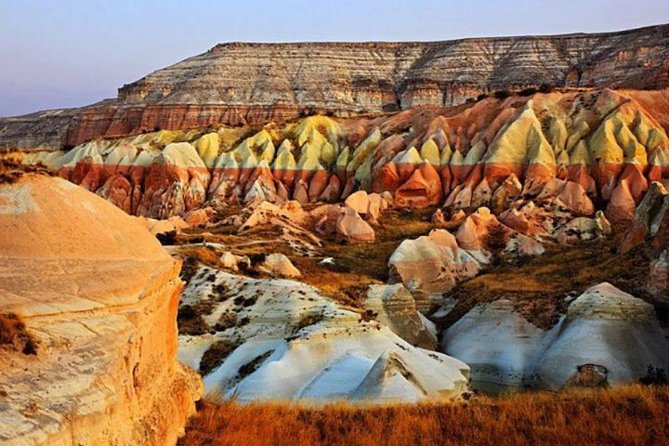
The Cappadocia Region of Anatolia has a history of thousands of years in social, political and cultural terms throughout history due to its geological and topographic features. Cappadocia has always maintained its geopolitical importance due to its geographical location. Particularly during the Assyrian Trade Colonies, Hittite, Seljuk, Roman and Byzantine Empires, the fact that the trade routes coming from east-west and north-south were located at the junction point increased the geopolitical importance of the region. In Cappadocia, where is one of the most characteristic landscapes of the world, surface forms developed due to volcanism, tectonism and erosion. The highest point of the region is the peak of Erciyes with 3917 meters and Hasandağ complex with 3268 meters. The Büyük and Küçük Hasan Mountains, the Melendiz Mountain and the Keçidoyran Mountain between them have a magnificent structure in Central Anatolia with their heights reaching up to 3300 meters and their smooth cone shapes. The geological structure of the Cappadocia Region is formed by the gas, solid and flowing substances throw out from volcanoes. Cappadocia Region has become a preferred center in almost every period due to the fact that volcanic lands have fertile soils and large tuff plates formed by ignimbrite eruptions create splits by rivers to provide protection and shelter. Information derived from archaeological excavations and surveys in Cappadocia Region, there are cultural remains of Paleolithic, Neolithic, Chalcolithic, Bronze Ages, Iron Age and later Hellenistic – Roman and Byzantine and Seljuk Periods which constitute the basis of tourism economy of the region today.
“Cappadocia Tablets” this is the first written document about Cappadocia and Anatolia as well. These tablets found in Kayseri Kültepe (Karum/Kanes) in two thousand years B.C. The first cultural traces in the Cappadocia region date back to the Lower Palaeolithic period with the widespread use of obsidian stone.
Meaning and Origin of the “Cappadocia”
There are many different ideas about where the origin of the name Cappadocia comes from. The ideas below are, the generally held in mind about the origin of the Cappadocian name.
Katpatuka : Which means Land of the Beautiful Horses in Persian Language.
Kapadoks – Cappadox : Former name of the Delice River, one of the important branches of Kızılırmak (Halis) River. Besides that son of the Assyrian King Ninias was named Cappadox.
Khepatukh : Chief God namein early Hittites period and in the same time Khepatukh means the country where is located below. Cappadocia is located south of the capital city of Hittites (Boğazköy/Hattusas).
History Of Cappadocia
The Cappadocia Region has a historical background of thousands of years which varies from social, political and cultural point of view due to the geographical features originating from its geological and topographic structure. In terms of political boundaries, the borders of Cappadocia have changed many times in history, and the region that includes Nevşehir-Aksaray-Kayseri and Niğde is defined as “Core Cappadocia”.
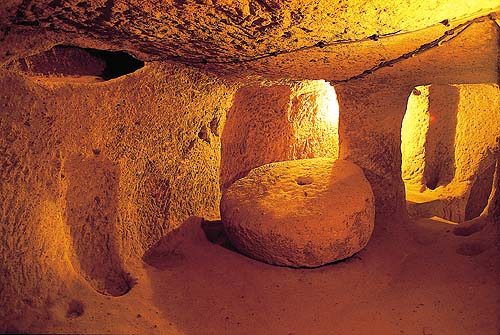
Cappadocia Undergraund
The region has an important position especially since it was located at the crossroads of the roads starting from the Early Bronze Age and east-west and north-south directions during the Assyrian Colonial and the Hittite Period. During the first millennium B.C, Nevşehir, located within the borders of the Tabal Country during the Late Hittite Period, carried a border zone between political structures in all periods with the advantage provided by the Kızılırmak River. Here you could get a brief information about Cappadocia.
Katpatuk : The word Katpatuk, which means nation in Armenian Language.
MOUNT AVLA AND OBSIDIAN
Mount Avla is 8 km south-southeast of Ürgüp district of Nevşehir, 2 km from Karlık Village. It is a flat settlement in the east of the Damsa Brook in the northwest. This settlement is special because we could observe the oldest human traces in Cappadocia.
Findings from the oldest settlement in Ürgüp and its vicinity are the flat settlement on the skirts of Mount Avla in the east of Damsa Brook (Tomissos).
When hunter and gathered tribes arrived the Cappadocia they discover the obsidian and its several benefits. Thus first human arrived to Cappadocia permanently.
Month Avla is one of the most mysterious place in the Cappadocia. Many people does not have any idea about this places. Unfortunately I have to inform that many tourist guides does not give any information about this unique place.
When we are talking about Avla Mount we must mention about Obsidian. Obsidian is a volcanic glass. When volcano erupted the flowing lava get suddenly cold and it is became very characteristic volcanic glass. There are many benefits of the obsidian. Before obsidian people were using flint stone but when we compare the obsidian and flint stone there are huge difference between them. Obsidian is sharper and more effective. Thanks to obsidian people were doing butchery works faster. They were shaving their self better than before as you may appreciate that this is very important for the health. People met with their face better than before because they use obsidian as a mirror. For hunting obsidian became indispensable. Intercultural relations started with obsidian. By the exchange people started to make trade each other. Archaeologist found Cappadocian obsidian in the North Syria. It is show that people started the relation in the Palaeolithic Era. There are many features of the obsidian we could write thousand pages about this unique stone.
The first obsidian findings in Avla Dağ were determined by Giorgio Pasquare on behalf of the Mineral Research Exploration Institute in 1963 in Ürgüp and its surroundings. In these studies, a large amount of obsidian and chip finds were found. According to this studies we learn that Avla Dağ is probably a region within the hunting grounds of hunter and gatherer groups. It is believed that it was used as a camping place both in the Pottery Neolithic Age and in the advanced Pottery Neolithic Age.
I hope the value and importance of the Avla Mount will be more known better in terms of Cappadocia history in the coming days. Cappadocia is not only Hot Air Balloon or Fairy Chimney. As a tourist guide we have to introduce the first humans of the Cappadocia. We must explain them to the world, we must remember them with respect. https://www.gomedavalleytravel.com/tours/cappadocia-balloon-tour/